
Southbourne
Thank you for visiting our engagement website. This website presents our emerging ideas and proposals for how development could come forward at Land North of Gosden Green in Southbourne.
Hallam Land have been working alongside a team of design and technical experts to evolve design proposals.
We are keen to hear your thoughts on the work we have undertaken and the proposals developed to date. Your comments and feedback will be helpful for us as we evolve our design proposals further in readiness for submitting an outline planning application later this year.
A feedback questionnaire can be found at the bottom of this website. We are inviting feedback until Monday 1st December.
Introduction to Hallam Land
Hallam Land are respected as being one of the UK’s leading land promoters. Working closely with landowners, partners and stakeholders, we have a successful track record of bringing forwards high quality, well designed places where people want to live. Our commitment to creating sustainable communities is proven by the provision of thriving places to work, green spaces to enjoy, improved transport networks and community facilities alongside these homes.
Our proactive team has the experience to ensure that each of our developments is well planned, enhances the character and qualities of each unique site and meets local needs and ambitions for growth.
As part of the Henry Boot Group, we recognise our duties to the environment and the communities in which we operate. Our people, partners and communities continue to trust our reputation, respect our expertise and value our team’s forward thinking approach.
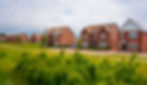
Here are some examples of Hallam Land’s recent developments where high quality new homes have been designed and delivered alongside public open space and supporting infrastructure. Local character and materials are reflected in the design of the new homes which are laid out to protect existing trees and hedgerows within extensive new green infrastructure.
_Colour%20(Endorsing%20line).png)

Handcross
Southbourne
Site Location
Land North of Gosden Green, Southbourne
The site is located to the west of Southbourne and extends to approximately 8.5 hectares.
Tuppenny Lane borders the site to the west with residential properties beyond where an application for 84 new homes and new open space has recently been consented.
Along the northern edge runs the rail line beyond which is agricultural land, residential development and Bourne Community College.
To the south of the site is Tuppenny Barn education centre and residential properties.
The eastern boundary is bordered by open space including allotments with residential properties beyond. Alfrey Close and Lawley Avenue provide access extending to the eastern site edge.
Tara Perry Road provides access from Main Road to the south-east corner of the site.
Public footpaths run along the western and part of the northern boundaries providing access into the wider landscape. A public footpath runs along the southern part of the eastern boundary before turning eastwards providing access towards the rail station.
The land is generally flat with a gentle fall from north-west to south-east and is currently used for arable agriculture. Hedgerows run along the site edges with a small group of trees located in the south-eastern corner.
Southbourne rail station and the amenities on Stein Road are located approximately 600m to the east of the site. Bus stops on Main Road are approximately 100m from the site edge.
Aside from some noise related to passing trains and localised areas of surface water flooding, the site is free from constraints.

Strategic Link Road & Rail Crossing
Currently only two points of access across the rail lines exist within Southbourne, leading to severance and lack of permeability and congestion and delay on the local road network. In response, the Parish Council included a proposal in their 2015 Neighbourhood Plan for a new strategic link road and bridge crossing over the rail lines to the west of Southbourne, and land was safeguarded for this purpose. Whilst this policy was deleted from the most recent Neighbourhood Plan (November 2023), the Parish Council acknowledge that “if Southbourne is to expand further in future a separate road and cycle bridge would be required to provide an alternative route to Stein Road”. In the meantime, the safeguarding, a condition of the adjacent planning permission, remains in place until 10 June 2046.
Whilst no detailed designs have been prepared to date, measures have been put in place to protect the ability of the Parish Council to deliver this infrastructure in the future as illustrated on the plan below.
The conditions associated with the safeguarded land require for it to be maintained in its current use, free from any development. This is an important consideration in the evolution of design proposals for our development.

Opportunities & Structuring Principles

A series of key principles have been developed to shape and structure our emerging development proposals. These have been evolved following site visits and observations and technical inputs from the consultant team. The key principles are:
Prioritise active travel connectivity to, from and through the development, providing connections with nearby neighbourhoods, open space, public transport services and amenities.
Provide new, high quality active travel connections between Hermitage and Southbourne.
Create new areas of public open space to connect with the existing surrounding network.
Create an open space network which can complement the ‘Green Ring’ proposals for Southbourne.
Create a range of wildlife habitats to connect with and supplement surrounding ecological features to support nature recovery in the local area.
Create a landscaped northern edge to contribute towards mitigation of noise from passing trains.
Create a high quality landscape gap between Southbourne and Hermitage.
Create a new vehicular access via Lawley Avenue.
Protect the safeguarded route for the strategic link road and associated rail crossing.
Consider opportunities for delivering part of the strategic link road within the layout of the development.
Integrate sustainable new homes which reflect the adjacent built form and character within a high quality landscape framework.
Connect with existing public rights of way.
Support the implementation of an improved Public Footpath crossing over the rail lines.
Green Ring Concept Plan
Proposed originally by the Parish Council, the Green Ring will see the creation of a new open space loop for Southbourne. The plan below illustrates how the open space provided as part of this proposed development could support and enhance the Green Ring for Southbourne.

Development Concept
The emerging development proposals have been evolved in response to the surrounding context – such as views, adjacent land uses and built heritage – and characteristics of the site – such as green infrastructure, access, hydrology and ecology. In addition to this, our engagement with the District Council through a Pre-application process has also helped shape the proposals presented.
They include up to 110 high quality and sustainable new homes set within a rich landscape framework with a main access via Lawley Avenue and network of supplementary walking and cycling routes.
We welcome your feedback via the questionnaire at the bottom of this page.

Landscape and Open Space
A welcoming, high quality and accessible open space network is proposed, comprised principally of an east-west green corridor and a north-south area of parkland. These new spaces will accommodate a variety of functions including walking routes and exercise trails, play spaces, wildlife habitats and flood protection measures.
They will provide valuable connections to the surrounding open spaces and public rights of way networks to the north, west and east, complementing the Neighbourhood Plan ‘Green Ring’ for Southbourne.
Within this wider open space network, the parkland and green corridor will offer valuable opportunities for people from the surrounding areas to meet, socialise and exercise whilst also establishing a permanent landscape separation between Hermitage and Southbourne.
Along the northern and southern boundaries, new areas of tree and hedgerow planting will supplement existing green infrastructure providing improved habitat connectivity. Where new homes are located parallel with the rail lines, appropriate noise mitigation measures will be integrated within the areas of new planting.

Built Form Character
Within this landscape framework, new homes will be arranged within two parcels towards the east of the site.
The new homes will be designed to be low water and energy efficient and will include opportunities for energy generation through the considered layout for solar gain and the use of technology such as photovoltaics.
The design and materials of the new homes will reflect the character of the local area in order for the new homes to integrate with the surrounding area. Building materials may include bricks, weather boarding, timber frame and render and slate and clay roof tiles.

Access and Movement
The main access into the development will be from Lawley Avenue providing for pedestrians, cyclists and vehicles.
To support the Parish Council’s plans for the strategic link road a section of it is proposed to be delivered as part of the vehicular access for the development.
There will be no vehicular access from Tuppenny Lane or Tara Perry Road.
A network of walking and cycling routes will extend through the development and open spaces providing connectivity with the surrounding communities, bus stops, open spaces and public rights of way.
Pedestrian connectivity between Hermitage and Southbourne will be improved with an extended footway network connecting Tuppenny Lane with Garsons Road providing improved active travel access to and from Southbourne rail station and nearby amenities.
Provision is made to accommodate an improved Public Footpath crossing over the rail lines as part of the network of active travel measures within the development.
The new development will include a series of streets integrating walking and cycling, planting and public realm features such as traffic calming measures and seating.

The consultation period for this development has now closed.
We are currently reviewing the feedback received.